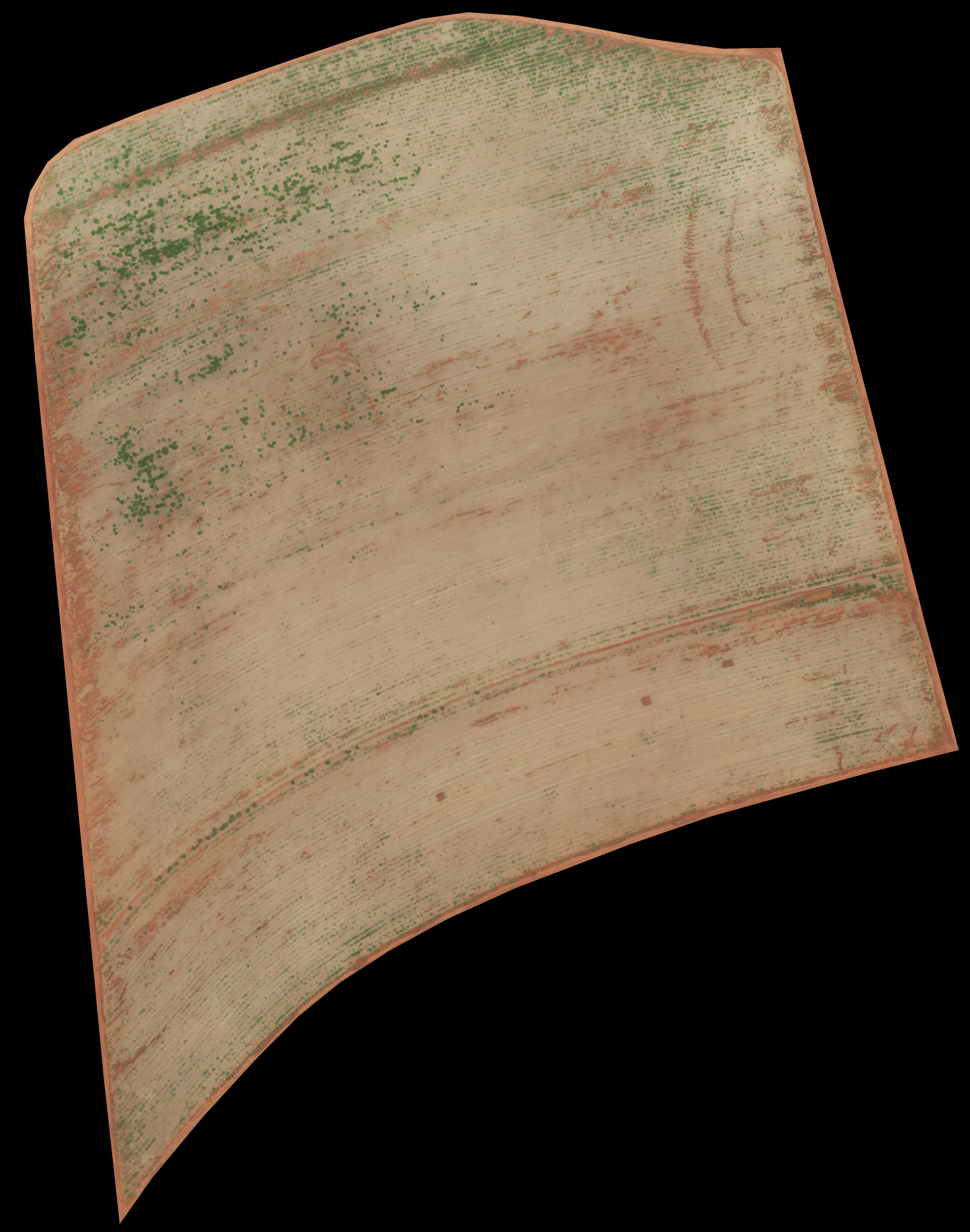
This page contains our Orthomosaic Dataset of RGB aerial images for Weed Mapping and Segmentation and its Ground Truth (GT). It depicts a sugar cane plantation in Northern Brazil, captured as a single UAV-acquired sugarcane field orthomosaic. The image was captured from an Horus Aeronaves (https://horusaeronaves.com/) fixed-wing UAV employing a visible light RGB Canon G9X camera. The UAV captured the data following a flight altitude of 125 to 200 meters, resulting in an approximate spatial resolution of 5cm/pixel.
The images can be downloaded at full resolution by either accessing the direct links under the illustrative low-resolution images below or by clicking at the images themselves.
Contents
Original Image
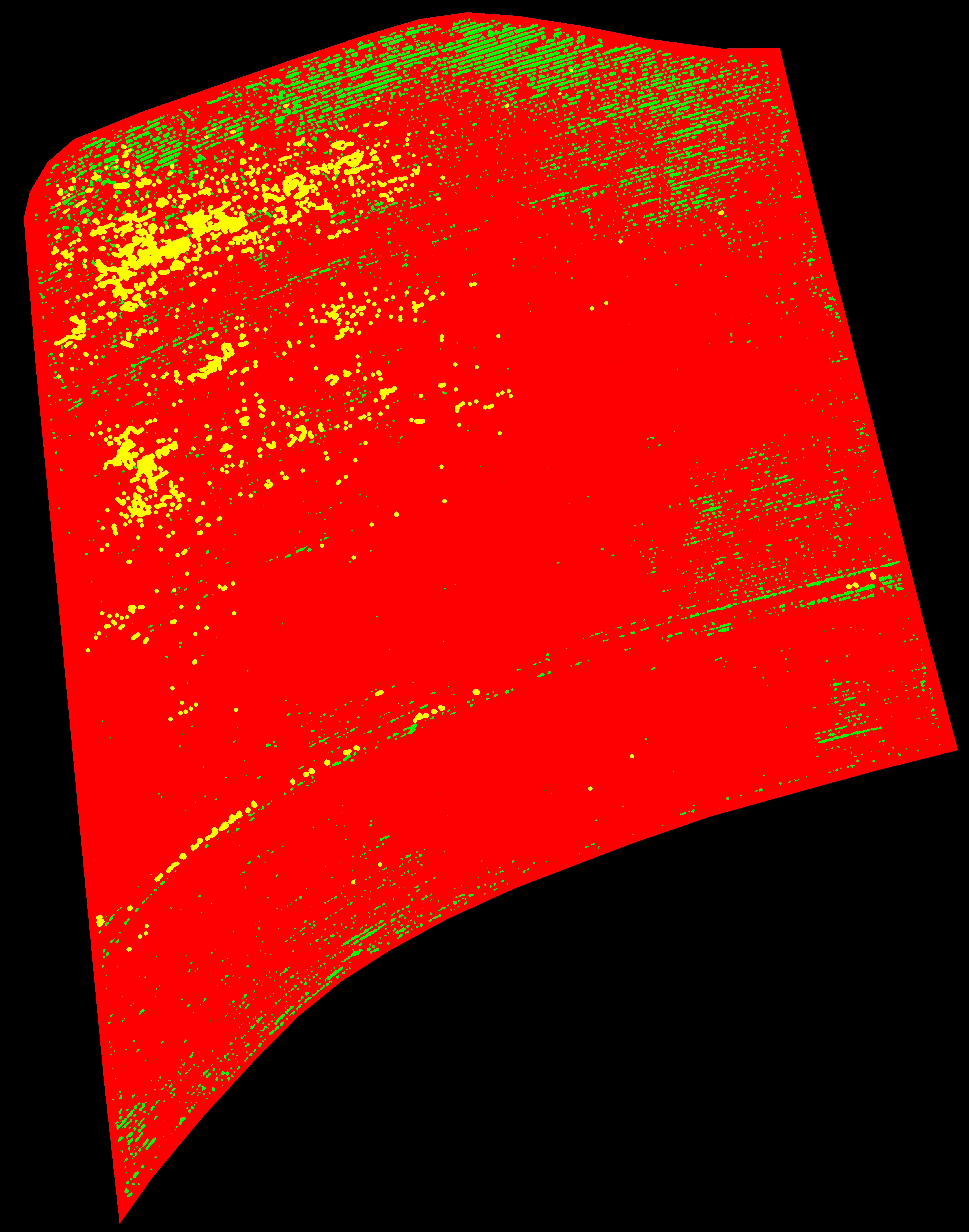
Ground Truth
From the dataset an expert biologist produced a human-made ground truth (GT). The expert classified the whole image manually, using the GNU image manipulation program (GIMP). All pixels of the image were classified into three classes: crop row (green), weed (yellow) and background (red). Out-of-boundaries pixels are black. This GT representation allows the direct usage of the GT in machine learning environments that employ the Pascal VOC standard.
[Link for direct download (ground truth image)]
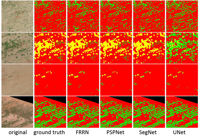
Exemplar Results
Code
The Jupyter Notebook employed to generate our results is available in the following repos:
- Institutional Git: https://codigos.ufsc.br/lapix/Weed-Mapping
- Author’s private Git: https://github.com/awangenh/Weed-Mapping
Refer to the jupyter notebook installation guide or import the file with Google Colaboratory to visualize the code.
Acknowledgements
We wish to thank Horus Aeronaves (https://horusaeronaves.com/) for acquiring and offering the dataset. There are no conflicts of interest.
This work was the result of a collaborative effort of a team of engaged researchers:
- Alexandre Monteiro <xandemont@gmail.com>
- Paulo Cesar Pereira Junior <pcpereiraj@gmail.com>
- Antonio Carlos Sobieranski <asobieranski@gmail.com>
- Rafael da Luz Ribeiro <rl.ribeiro@outlook.com>
- Marcelo Ricardo Stemmer <marcelo.stemmer@ufsc.br>
Related Publications
- Weed Mapping on Aerial Images – A Systematic Literature Review. Paulo César Pereira Júnior, Alexandre Monteiro and Aldo von Wangenheim. Technical Report INCoD/LAPIX.01.2019.E (May, 2019) [PDF] [DOI: 10.13140/RG.2.2.34979.71204]
Citing this Dataset
@misc{WeedMappingDataset2019,
  author = {Monteiro, A.A.O. and von Wangenheim, A.},
  title = {Orthomosaic Dataset of RGB aerial Images for Weed Mapping},
  year = {2019},
  publisher = {LAPIX/UFSC},
  journal = {INCoD Datasets Repository},
  howpublished = {\url{http://www.lapix.ufsc.br/weed-mapping-sugar-cane}}
}